Address Geocoding software solutions
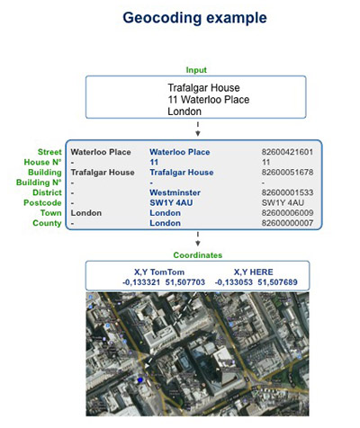
Address geocoding involves assigning precise spatial and territorial data and codes to specific addresses. In the preliminary phase this involves georeferencing which means assigning precise map coordinates to the address, to guarantee correct and certain map location.
Need to locate a postal address on a map?
In just a few minutes you will be able to convert a postal address into precise geographical coordinates (latitude and longitude) and vice versa. Then you’ll see the location on a map.
HOW TO GEOCODE ADDRESSES WITH EGON SOFTWARE
Egon is a very powerful geocoding software package, which enables geocoding on multiple record databases, providing the validated format and map coordinates for any address.
With the rapid development in geolocalisation technology and services, and the growing availability of territorial data from all over the world, it is crucial for each business field to carefully reconsider the strategic value of addresses and precise geographic data.
Egon relates the data to the territory and by focusing on the highest level of details, gives a precise representation of the data, backing up GIS applications and creating catchment basins, areas of responsibility and of addresses, etc.
The software is not just limited to basic georeferencing functions, but can also satisfy very sophisticated and diverse geocoding needs:
- Assigning taxable zones
- Proximity and immediate calculation of the distances as the crow flies and on foot
- reverse geocoding
- points of interest
- localisation by street name
- identifying crossroads (corners)

